How it all started...
- arewethereyetrambl
- Mar 14
- 3 min read
I’ve always liked a nice map or pictorial representation – tube map, mathematical drawing, puzzle – I’m not exactly sure when this nerdiness started.
As a young child I also found myself drawn to physical activity. I revelled in the joy of simply moving. Dolls and pink fluffy things were not for me. I was always looking for a tree to climb or a wall to cartwheel along. My parents would take us on the gentle circular country walks which were shown in their favoured newspaper. We loved a decent stile!

My love of movement eventually led to a career in contemporary dance. I considered a job as a Benesh notator, basically a maker of dance maps, but settled on teaching. This involved a lot of choreography. I often began with spatial diagrams and ideas for paths in space which would look interesting and convey the theme. I would draw detailed maps to show where and how the performers would move from place to place.

I began to use actual maps in earnest when I got my dog, Bernard, about 16 years ago. Fields and woods excited both of us. Pavements did not. I now know that this is common for neuro-divergent individuals. The sights, sounds and smells of the natural world were a balm for my overly busy brain. I bought a local map and Bernie and I began to explore! The task of working out the route gave me the dopamine hit I was missing. Bernie enjoyed chasing squirrels, rolling in fox poo and munching on wild salad.

Eventually Bernie slowed down. I realised I wanted more. I needed a new challenge. I saw a programme on tv about a coastal feature – The Street, near Whitstable. I’d never seen it, but it was on maps (old ones). So I had to find it! I’d also recently read “The Salt Path” and while standing on this narrow spit of land, gazing out to sea, I had a revelation. I would navigate the entire coastline of Kent! I acquired maps and set off.

I took photos, wrote poetry, journaled, drew some (poor) sketches, and when I reached the end of my journey I continued into neighbouring East and West Sussex. Then I ventured inland.

I wanted to tackle more challenging landscapes, so I signed up for a basic navigation course up on the moors of the Peak District – a much harsher landscape requiring a keener eye and greater understanding.

There are things a map can’t tell you. Tide times, mud, cows, things which change from day to day or even hour to hour. Footpaths may be blocked, locked or even invisible.

Back then I always walked alone (still do regularly), but now I also enjoy the company of the like-minded women I have met in the Kent circle of the international women’s group, Sole Sister Ramblers. They often laugh (gently) at me with my map, silly hats and over-stuffed rucksack.

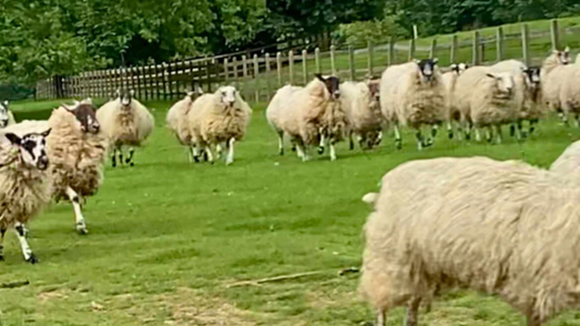
After 3 decades, I left teaching at the start of 2023, burnt out and numb. I struggled to find a new direction but kept returning to maps and walking. They make my heart sing and my feet dance. I returned to the wild moors to complete the harder NNAS Silver award. The navigation bug had well and truly bitten me (although fortunately the ticks and other nasty nibblers have not!) I have waded round headlands, scaled gates, wriggled under wire fences, lost and found hats, left my shoes in deep mud, got mentally “stuck” on ledges, and been chased by sheep.
But most of all I have found so much joy. At some point among the crashing waves, quiet hedgerows and corn-filled fields, I discovered my new self. I realised that map reading and walking are where my future lies. I plotted… literally!

My own future map is still being drawn and I’m hoping it leads to many more exciting adventures (preferably without too many cows).
See you on the trails!!!
Comments